FloodChaser Studio and FloodChaser Master
Single Event Flood Hydrology Simulation
Haycock Environmental Consultants Limited
Independent Hydrologist and Waterscape Consultants
Sample Datasets:
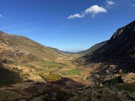
Nant Ffrancon, North Wales
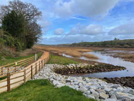
Lower Otter Esturary
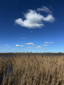
High Fen Drove (Fenland, Norfolk)


Floodchaser Studio is a single event flood hydrology simulation tool that lets you explore and play with how water moves through a digital terrain model using an Manning's Equation solver. So, import your digital terrain model (.asc or edit a geotiff) for the landscape you are interest in, and to be begin with, just select a pixel and allocate a flow that you want that pixel to receive. Select where you want your output file to be saved, and select "Run". Click and Play. Don't worry about soil properties, infiltration rates and soil water simulation, you can build these functions into your simulation as you get used to the concepts. This is not an engineering tool, but a tool to explore ideas and water behaviour and ask questions about hydrological processes. For professional, this is maybe a faster way to explore issues before diving into parameterising a 1D or 2D hydraulic model. FloodChaser Studio allows you to run simulations with spatially uniform values for the landscape and its soils. FloodChaser Master allows a range of parameters to be spatially mapped.
This app has been developed by Dr N Haycock (D.Phil., Oxon), a consultant hydrologist who specialises in river, wetland and lake hydro-chemistry. In 2008 we tried to advance the implementation of MPI and GPU acceleration of Bristol Universities “LisFLOOD-FP” model and had partial success (version 2). A lot of water has passed under the bridge since then and in 2026 we started building Floodchaser from the ground up, focusing on pixel to pixel water transfer functions and accelerating the key processes with new GPU resources based on the macOS. Simulations that took 17 hours in 2008 and been run now been run less than 120 seconds (e.g., Boscastle Flood 2004). LisFlood-FP version 8.2 remains the core "floodengine", but with some macOS tweeks for Metal-GPU processing. The second aim of Floodchaser was to bring together a range of flood simulation data preparation processes and have one app to import and edit digital terrain models, construction simple flood hydrography and rainfall hyetograph and apply these inflows. Apart of spatially mapping the data (export .MOV or .rawf32 files), I wanted to be able to click and mark where "stage boards", "dip well" and "gauge stations" should be placed in the model and plot this data. Currently I have avoided having a 1D channel model, because of CPU / GPU issues, but some of my “real” projects depend on water pumps or gravity syphons, so I have included these functions in the model, which has been fun.
So this app is a simulation tool, aimed to allow the user to explore landscape hydrological ideas and ask questions. It is not an engineering tool. If you want an engineering tool then there are a raft of specialist flood software programme on the market, with their associated training and certification programmes. After playing with some ideas, maybe you will be more focussed on key issues if you have access to these engineering tools, or you will want to get more involved with landscape hydrology.
FloodChaser Master is aimed at users who want to simulate single event flood or rainfall runoff process, but have more refined spatial variables like soil depth, soil porosity, soil infiltration rates or subsurface Darcy variables. We have included pre-processing mapper to allow these variable to be mapped and imported into the model, or just import you own .asc grid data. FloodChaser Master allows you to set up 6 simulation and auto-run them in sequence. Again, Floodchaser (Studio and Master) is about exploring concepts around landscape water behaviour, so the auto-simulator is aimed at exploring ideas, not engineering solutions.
Nant Ffancon, Ogwen Valley, was an early river restoration scheme (1998) aimed at restoring the channel which had been deep dredged in the 1960. The dataset allows used to look at steady state flow through this amazing valley and asked questions around flood routing and ideas around habitat creation opportunities. (ZIP data contained LiDAR data for the site, see Crown Copyright 2026 OGL v3.0)
The Lower Otter Estuary was extensively restored in 2016-2020 and our initial modelling of the flood hydrology of the valley helped identify key river-floodplain connection issues and the impact of 1800 river engineering. This dataset is aimed at looking at variable inflow and how a flood wave moves down the valley (pre restoration. (ZIP data contained LiDAR data for the site, see Crown Copyright 2026 OGL v3.0)
Nattergal High Fen Wildland is a 300-hectare former farm in West Norfolk. Purchased in 2022 by Nature recovery company, Nattergal, High Fen has recently completed a multi-year peatland restoration project, resulting in the rewetting of 150 hectares. This scheme is dependent on the use of syphons which allow excess winter water to be abstracted from an adjacent river to maintain the wetness of the site and its soils. The sample dataset allows users to explore the water distribution across the site with the operation of three syphons, as installed in 2025. (ZIP data contained LiDAR data for the site, see Crown Copyright 2026 OGL v3.0)

Data Privacy Statement:
FloodChaser Studio and FloodChaser Master does not share any user information or generate any software / code analytical data with ourselves or any third party. The app does have a small runtime LOG window within the app which can provide feedback to the user on any issues with the code or simulation being run, but this information is local to the users computer
Copyright
FloodChaser (Studio, Master): Copyright © 2026 Haycock Environmental Consultants Limited. All rights reserved. Author: Dr N E Haycock.
LISFLOOD-FP (v8.2): Copyright © 2026 Professor Paul Bates, University of Bristol.
UK (England and Wales) LiDAR Data is Crown Copyright (2026) with "All content is available under the Open Government Licence v3.0, except where otherwise stated"
All product names mentioned are trademarks or registered trademarks of their respective owners. No part of this publication or the accompanying software may be copied, reproduced, distributed, transmitted, transcribed, stored in a retrieval system, or translated into any human or computer language, in any form or by any means, whether electronic, mechanical, manual or otherwise, or disclosed to any third party, without the prior written permission of Haycock Environmental Consultants Limited (http://www.hec-ltd.co.uk/HEC-Limited/index.html).
Exclusion of Warranties
To the fullest extent permitted by law, the Software is provided "as is", and Haycock Environmental Consultants Limited gives no warranties, representations or undertakings of any kind, whether express or implied, in relation to the Software. In particular, all terms implied by statute or common law — including any implied terms as to satisfactory quality, fitness for a particular purpose, and the exercise of reasonable skill and care — are excluded to the fullest extent permitted by law. Haycock Environmental Consultants Limited does not warrant that the Software, or any results obtained from its use, will be correct, accurate, reliable, complete, current, error-free or uninterrupted. The entire risk as to the results and performance of the Software is assumed by you.
Limitation of Liability
Nothing in this notice excludes or limits the liability of Haycock Environmental Consultants Limited for: (a) death or personal injury caused by its negligence; (b) fraud or fraudulent misrepresentation; or (c) any other liability that cannot lawfully be excluded or limited. Subject to the above, and to the fullest extent permitted by law, Haycock Environmental Consultants Limited shall not be liable, whether in contract, tort (including negligence), breach of statutory duty or otherwise, for any indirect, special or consequential loss or damage, or for any loss of profits, loss of business, business interruption, loss of anticipated savings, or loss or corruption of data or information, arising out of or in connection with the use of, or inability to use, the Software, even if Haycock Environmental Consultants Limited has been advised of the possibility of such loss or damage.
Governing Law
This notice, and any dispute or claim arising out of or in connection with it, shall be governed by and construed in accordance with the law of England and Wales, and the parties submit to the exclusive jurisdiction of the courts of England and Wales.
Acknowledgement Request
Haycock Environmental Consultants Limited requests (but does not require) that you acknowledge the use of FloodChaser (Studio, Master) in connection with any published or publicly available images generated by the Software..